Pamir Plateau

The Pamir Plateau is located in southeastern Central Asia and the western end of China, spanning Tajikistan, China and Afghanistan. "Pamir" means "Roof of the World" in Tajik. The plateau is 4,000-7,700 meters above sea level and has many peaks. As early as the Han Dynasty in China, the Pamir Plateau was called "Congling" because of the lush green onions or cliffs. It is also called Buzhou Mountain. The southern and central routes of the ancient Silk Road passed through here, and then led westward to West Asia, South Asia and Europe.
The Pamir Plateau is divided into two parts: the eastern Pamirs are relatively open and consist of two northwest-southeast mountain ranges and a group of river valleys and lake basins. The western Pamirs consist of several roughly parallel northeast-southwest mountain ranges and valleys, with a large relative height difference and characterized by high mountains and deep valleys.
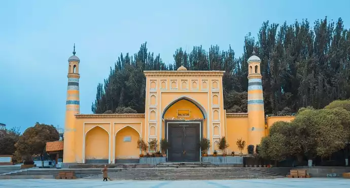
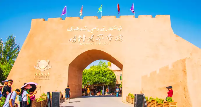
When visiting the Pamir Plateau, people mainly visit Taxkorgan Tajik Autonomous County in the northeast, as well as Muztagh Ata Peak, Stone City, Khunjerab Pass, etc. Stone City is located in the north of Taxkorgan Tajik Autonomous County, about 3,100 meters above sea level, with extremely steep terrain. It is a famous ancient city site on the ancient Silk Road in Xinjiang.
Muztagh Ata is majestic and covered with snow all year round. It is known as the "Father of Icebergs". It is the most beautiful scenery on the China-Pakistan Friendship Road (National Highway 314) and one of the most desired peaks for mountaineering enthusiasts. The Khunjerab Pass is the only land entry and exit passage from China to Pakistan, and is also an important gateway to the South Asian subcontinent and even Europe. Here is the famous China-Pakistan No. 7 boundary monument and the spectacular national gate.
User Reviews

"Pamir" means "Roof of the World" in Tajik. Some people say that the roof of the world is not the Qinghai-Tibet Plateau? Maybe the Qinghai-Tibet Plateau is the roof of the world in the minds of Tibetans, and the Pamir Plateau is the roof of the world in the minds of Tajiks. In ancient times, there was no such accurate measurement method, and transportation was inconvenient. People in the two regions may not have compared which one had a higher altitude. In 1941, the British John Wood published an expedition into the Pamirs. The book said that the locals called this area Bam-i-Duniah, which means Roof of the world. This should be the true origin of the "Roof of the World".
After research, some historians believe that Pamir is the Buzhou Mountain in ancient legends. Legend has it that in ancient times, the water god Gonggong had always been at odds with the fire god Zhurong, and the two fought a world-shaking battle. As a result, Gonggong failed and fled to Buzhou Mountain, where he broke it in anger. Unexpectedly, the sky was supported by Buzhou Mountain. When Buzhou Mountain fell, half of the sky collapsed, and later there was the legend of Nuwa mending the sky.
During the Han Dynasty, the Pamir Plateau began to be called "Congling", mainly because of the abundance of wild onions in this area. Some people also say that it is named because of the lush wild grass and verdant cliffs. Kunlun Mountain, Karakoram Mountain, Hindu Kush Mountain and Tianshan Mountain meet here. The average altitude of the entire plateau is above 4,500 meters, and the main peaks are all above 6,000 meters. It is an important passage for the ancient Silk Road to India in the south and Afghanistan and Iran in the west.


The movie "The Visitors Under the Iceberg" takes place in Taxkorgan Tajik Autonomous County on the Pamir Plateau. This movie has left a deep impression on many people about this plateau. After so many years, the beauty of the Pamirs remains the same.
If you haven't been to the Pamirs, you won't know how vast the world is.
If you haven’t been to Pamir, you won’t understand the rich customs of the Western Regions.


The scenery is beautiful all the way, and self-driving is recommended. Although it is a plateau, there is no altitude sickness. On the way to the Khunjerab Pass, you can stop the car and touch the water. The cold water comes from the snow-capped glaciers. You can also see brown marmots and listen to their strange calls, but don't touch them, they will spread plague. Be sure to leave enough time on the Pamir Plateau, because the scenery is so beautiful!


Speaking of the Pamir Plateau, we have to start with a night drive. We set out from Kashgar that day, wandering around, stopping and starting. It was almost afternoon when we arrived at a border checkpoint. Since we didn't do any travel guide in advance, we didn't know that we needed to apply for a border pass to Taxkorgan. When we returned to Kashgar to apply for the pass, it was already sunset. Mr. Shu, a skilled driver, insisted on driving over again. It was already late at night when we passed the checkpoint for the second time. To be honest, I was a little nervous, after all, we had to drive for 6 hours on the plateau snow mountain road.
It started to rain right after we got there, and then it turned into small snowflakes, and then the moonlight shone brightly. We occasionally encountered a mountain cat with shiny eyes crossing the road. The most exaggerated thing was a few wild camels, with tall, thin and long legs, and a clear expression on their big faces, staring at us intently, and stopped in the middle of the road to see if they would pass. Mr. Shu was stunned and walked through them without slowing down. Fortunately, the camels did not move around, and I was scared just thinking about it. Finally, we arrived in Tashi County safely. This day can be recorded in my personal Guinness record.
When I woke up in the morning, the snow-capped mountains in the distance came into view. It was a nice day.
We finally got to see the real face of the Pamir Plateau. How can I describe it? Words and pictures probably can't express even one ten-thousandth of the beauty. For the first time, I felt that all cameras were useless here. I can only say that last night's run was worth it.


There are several important scenic spots on the Pamir Plateau, including Baisha Mountain, Baisha Lake, Muztagh Ata Snow Mountain (the father of the glacier), Kongur Peak, Kongur Jiubie Peak, and Karakul Lake. Snow-capped mountains, wetlands, lakes, and flowers blend together, creating a majestic atmosphere. In the azure and vast sky, you can also see two armed helicopters or two fighter jets patrolling together. I don't know why drones are not allowed in Baisha Lake, but they can be placed freely in Karakul Lake. The two batteries were all used up after flying for an hour. Although Ta County is small, it borders three countries. Tajikistan, Afghanistan, and Pakistan. Tajik girls are very beautiful and hospitable. When we visited their homes, they also took out their unique ethnic costumes for us to take pictures. For details, please refer to my travel notes. http://www.mafengwo.cn/i/17809219.html


This section of G314 "Road to Heaven" is also known as the China-Pakistan Friendship Snow Mountain Highway. As the name suggests, it leads to Pakistan outside the border. The initial journey was not very novel. The only cool thing was that riding a motorcycle did not have to be limited to 30-60 miles per hour like a car. Since entering the vast southern Xinjiang, it has been a long time since I last drove a corner. Now crossing the Pamirs is a paradise for the iron cavalry. Twist the throttle, let the engine roar wantonly, and all kinds of S-bends swept by in the wind. Ahead, the peaks are endless. Just after arriving at a pass, there is no time to stop, and we get into another higher mountain. At this moment, we are like a beast rushing towards a group of giants, running and roaring, and as the horizon rises, we are getting more and more bloodthirsty!


The most anticipated thing in Xinjiang is the westernmost part of China ~ Pamir Plateau. Starting from Kashgar, passing Baisha Lake ~ Karakul Lake ~ Muztagh Ata Peak, and finally reaching Hongqi Lafu Pass. Although Hongqi Lafu is not open to visitors this year, the beautiful scenery along the way is the most shocking. P.S.... When you reach the snow-capped mountains, you feel like you are in Lhasa ~ Hehe ~ I hope you have good weather ~


Today, from the moment we entered the Pamir Plateau, with the help of the sunshine, the plateau scenery simply blinded everyone's eyes. It was a complete visual feast.


It is also one of the roofs of the world. The plateau is majestic and the biggest advantage is that the glacier is right in front of you without the worry of altitude sickness.


Located at the westernmost end of the motherland, you must go and take a look


Baisha Lake is the first gift from the Pamir Plateau to mankind.


Very good, very good, very good, very good, hahahaha


There are two legendary peaks and two lakes on the Pamir Plateau (Muztagh Ata Peak, Kongur Jiubie Peak, Karakul Lake, and Baisha Lake). On the Pamir Plateau, lives an ancient and mysterious ethnic group. They have pure European blood and all of them are extremely good-looking.


I went to southern Xinjiang in 2016 and took a bus from Kashgar to Taxkorgan. The road from Kashgar to Shahu was extremely bad. Once I got to Shahu, the road was flat. Along the way, I began to appreciate the beautiful Pamir Plateau. There were towering snow-capped mountains and long mountain ranges in both places. The most beautiful scenery was on the road!


Pamir Plateau + Taxkorgan County, recommendation: ★★★★★★, this is the first time in my life that I have rated a place with more than five stars. The most beautiful place is Pamir. I hope this is the last time I exceed my own standards and rate such a perfect place. Then let's talk about something practical.
1. The road conditions are very good, but the speed limit is very strict. There is speed measurement throughout the entire journey. And for some reason, there is only the starting point of the speed measurement under the camera, and the end point is rarely seen. The speed limit is 60 kilometers.
2. It was sunny and windy when I went there on the first day, but when I came back on the second day, it was dusty and I couldn’t see anything. The six-star scenery could be reduced to one star, so be sure to check the weather forecast.
3. There is no gas station when you leave Shufu County, there is only one when you get to Taxkorgan County, so please prepare your gas, otherwise the queue for gas in Taxkorgan County will make you crazy.
4. The Tajiks believe in the Shia sect of Islam. Don’t go into a restaurant and ask people if they have any wine.
5. The temperature difference on the plateau is huge, and the wind is also very strong. It hurts enough when small stones hit your face.
6. The Gaizi Border Inspection Station requires a border pass, so please prepare it in advance and apply for it in your local area
7. Don’t even think about the Hongqilapu Port. You can only go there if you have connections. So don’t waste your time.
Many people are getting better at taking photos, but their brains are empty. Please make a plan before going out, and don't ask Muslims if they have wine, such stupid questions
Figure 1 and Figure 2 show the sunny weather on the first day and the sandstorm on the second day.


Under the glacier-covered Muztagh Ata, Karakul Lake quietly accompanies it, and in the distance is the rolling Kongur Jiubie Peak. The white snow, the deep blue lake, the golden grassland in late autumn, and the herds of livestock that are contented, the scenery on the Pamir Plateau is just right.


The Pamirs (also known as Pamir), known in ancient China as the Congling Mountains, also known as Buzhou Mountain, where the ancient Silk Road passes. Located in the southeast of Central Asia and the westernmost part of China, it spans Tajikistan, China and Afghanistan. It is the confluence of many major mountain ranges in Asia, with an average altitude of 4,000-7,700 meters.
Buzhou Mountain is the name of a mountain in ancient legends. It was first seen in the Classic of Mountains and Seas: Great Wilderness West Classic: "Beyond the northwest sea, in the corner of the great wilderness, there is a mountain that does not fit in, and it is called Buzhou."
"Pamir" means "Roof of the World" in Tajik. The plateau has an altitude of 4,000 to 7,700 meters and many peaks. The plateau is the junction of two huge mountain belts on the earth (the Alps-Himalayan belt and the Pamir-Chukchi belt). It is also the gathering place of the main mountain ranges in the southern and central regions of the Asian continent, including the five major mountain ranges of the Himalayas, Karakoram Mountains, Kunlun Mountains, Tianshan Mountains, and Hindu Kush Mountains. It has undulating mountains, continuous winding, snow-capped peaks standing in groups, towering into the sky, and is known as the roof of the Asian continent. The highest peak of the Pamir Plateau is K2, located at the junction of China and Pakistan, with an altitude of 8,611 meters, and is the second highest peak in the world.
Whether you come here by self-driving or with a tour group, the first thing you need to know is its cultural history, from Gonggong hitting the Buzhou Mountain, the sky and the earth broke, to the Han Dynasty opening up the Western Regions and calling it the Congling Mountains because of its lush cliffs, and then to the Tang Dynasty calling it the Pamirs. All the historical and cultural accumulations have formed the roof of the world, including Zhang Qian's footprints in the Western Regions, the story of Tang Monk's journey to the West, and the negotiations between the Qing Dynasty and Britain and Russia. How can you not experience such a trade route connecting China with Central Asia and West Asia?
In summer, there are abundant grass and water, connected mountains and lakes, wind blowing through grasslands to the distant sky, and melted snow on ice cliffs turning into flowing water. In winter, everything withers, a heavy snowfall covers an area stretching for eight kilometres, and the majestic snow is dressed in silver for nine days, changing the color of the heaven and earth.


Reservoirs can be so beautiful. There is a free attraction on the way to Karakul Lake, the Bulenkou Reservoir, which seems to be also called Baisha Mountain and Liusha Lake.


The Pamir Plateau covered in snow is pure and quiet, with rolling mountains and snow-capped peaks towering into the sky. Under the snow-capped mountains are beautiful villages, quiet rivers, and cattle and sheep grazing on the grasslands. . .
All of this satisfies all my imaginations of the Pamir Plateau.


Walking on the Pamir Plateau feels like a dream, and it seems familiar. Everything in front of me is holy and pure, including the snow-capped mountains, lakes, and the eyes of the Tajik people.
The sun rises very late on the Pamir Plateau, and it is almost nine o'clock before dawn. When you see the national flag in the border areas of the plateau, you will feel a sense of pride.


Magnificent and magnificent, the mythical Buzhou Mountain, the ancient Pamir Mountains


At the end of December 2017, I went to Xinjiang for a trip. I bought a ticket from Urumqi to Kashgar. On December 31, 2017 and January 1, 2018, I chartered a car to Taxkorgan Tajik Autonomous County (abbreviated as Ta County) for two days and one night. There were almost no other tourists on the Pamir Plateau in winter. Although it didn't snow, it was very cold to watch the sunrise in the early morning. Even during the day, I couldn't get off the car for too long because the wind was strong and it was cold after a long time. But coming here is definitely worth it.


There were many beautiful views along the way. We stopped and walked and saw herds of alpine yaks grazing.
You can see camels strolling leisurely on the road; the snow on the top of the mountain never melts all year round, just like an old father with a white beard guarding the plateau and everything on the plateau. This is also a holy place that many climbers dream of.


Pamir means "Roof of the World" in Tajik. The plateau is 4,000 to 7,700 meters above sea level and has many peaks. It includes five major mountain ranges: the Himalayas, Karakoram Mountains, Kunlun Mountains, Tianshan Mountains, and Hindu Kush Mountains. It has undulating mountains, continuous and winding, and snow-capped peaks standing in groups, towering into the sky. The ancient city has a one-day tour to the Pamir Plateau, with three main attractions: Red Mountain, White Sand Mountain and Karakul Lake. Red Mountain is located at the confluence of the Gezi River and the Oytak River. Wucai Mountain, commonly known as "Red Mountain", is also called "Five-Colored Mountain". The reddish-brown mountain body with the setting sun like blood is unique. In the middle and low mountains of the Pamir Plateau, colorful mountains can be seen everywhere, and the landscape is very rich and peculiar. Sometimes in the same mountain body, you can see black, white, yellow, red, and blue colorful colors mixed in it, crisscrossing and intertwining. Baisha Mountain is located in the Pamir Plateau Mountains in Kashgar, Xinjiang. It is a must-go place to Karakul Lake. Karakul Lake, also known as Baisha Lake, is a plateau lake with an area of 44 square kilometers. The Kongur Jiubie Peak stands far away on both sides of Baisha Lake. Such a beautiful scenery makes the snow-capped mountains and lakes that have been sleeping for thousands of years appear more pure and quiet. Karakul Lake (also known as Karakul Lake), Karakul Lake, meaning "Black Sea", is 3,600 meters above sea level, 30 meters deep, and has a total area of more than 100,000 square kilometers. It is a rare alpine glacial moraine lake in the world. Karakul Lake is a plateau lake. The lake is surrounded by ice peaks and snow ridges, especially the surrounding Kongur Peak, Kongur Jiubie Peak and Muztagh Ata Peak, which add magical and beautiful colors to this lake.

Golden Grass Beach, White Sand Lake, Karakul Lake, Muztagh Ata Peak, Ancient Stone City... Charming Pamir welcomes you. 🚗10.29


Climbing up the Pamir Plateau, the place we pass through was called "Congling" in ancient times. It was the place where Zhang Qian, Ban Chao, Xuanzang, and Marco Polo crossed mountains and rivers in history. Crossing the Congling, you will reach the West Sea of the Four Seas. The border of the "world" within the four seas of the ancients was here. Historically, this road was difficult to walk on and was known as the "Blood Valley". King Mu of Zhou drove eight horses to this place, visited the Queen Mother of the West, exchanged gifts, and determined the border of China by the way. After that, this place became a major transportation route on the Silk Road.


The Long Xuanzang Road
Road to Pamirs, Xuanzang Road on the Pamir Plateau. I was too excited last night and didn't sleep well. As a result, I got stabbed on the plateau. I jumped and jumped at an altitude of 3,800, but I was panting as I walked. Then I had no supplies all the way. I didn't have breakfast until 5:30 in the evening. I was hungry and cold and had a gorgeous altitude sickness. Baisha Mountain, Liusha River, Kalekuli Lake, Muztagh Ata Peak, the autumn colors of the plateau in Taheman Township, Stone City, Golden Grass Beach, a visual feast, and the first plateau driving in my life. In short, the scenery is beautiful, but the people are mean. And don't ask me to criticize ERP tomorrow. I didn't even get P along the way.


What other scenery is not available in Xinjiang? The Pamir Plateau in southern Xinjiang allows you to experience the four seasons. Snow-capped mountains, lakes, grasslands, forests, Gobi Desert and glaciers are scattered in every corner of the Pamir Plateau, presenting a breathtaking landscape.


A highly recommended place to visit, the essence of southern Xinjiang's humanities, the simple folk customs of the Tajik people and the harsh living environment form a sharp contrast, which is shocking


A one-day trip to the Pamir Plateau is the best choice. The Baisha Mountain, Baisha Lake, Karakul Lake, and Taheman Wetland have desolate and vast scenery, and the sunshine is so strong that you can't open your eyes.


The scenery along the Pamir Plateau, snow-capped mountains and lakes
What is majestic? What is pure nature? Come to the Pamir Plateau! Kunlun Mountain will tell you everything!
Beneath the glaciers and snow-capped peaks of the Pamir Plateau, there are vast forests, lush meadows, and clear streams, presenting a beautiful scenery that combines both rigidity and flexibility with strong contrasts.
On the Pamir Plateau, with clouds, snow-capped mountains, deserts and lakes, I am sure this is where my soul is freest.


The scenery along the way is amazing! This proves the saying "The scenery is on the road"


The Pamir Plateau is a relatively large area, including the five major mountain ranges of the Himalayas, Karakoram Mountains, Kunlun Mountains, Tianshan Mountains, and Hindu Kush Mountains.


When I was a child, I heard about and learned about the "Pamir Plateau" in geography textbooks.
But at that time, I felt that this place was very mysterious and remote, and basically had nothing to do with me.
At the end of June 2018, I followed the "Lazy Uncle May" outdoor organization, traveled across southern and northern Xinjiang, participated in his event, and came to the "Pamir Plateau".
Kashgar in southern Xinjiang is a place that anyone can go to. However, if you want to go south from Kashgar to Taxkorgan and deeper into the hinterland, you need to apply for a border pass.
In addition to handling it at the tourist's place of registered residence, most people go to the Administrative Service Center in Kashgar to handle it.
Our convoy left Kashgar and headed for today's destination - the Khunjerab Pass. We left at around 9 o'clock in the morning, and after checking the dashcam, we should have arrived around 7:30 in the evening.
During this journey, you will pass by many beautiful scenic spots and see more scenery that you can’t name.
When the convoy approached Baisha Lake, I didn't know there was such a scenic spot, so I wasn't mentally prepared. It was when the convoy was driving normally that I felt the light in front of me was getting brighter and brighter! When I reached a high point, I found that the stunning green lake and the delicate white sand mountain in front of me corresponded to each other. It was as if I had arrived in a fairyland on earth!
To see Muztagh Ata, you don’t necessarily have to buy a ticket to enter the scenic area through the main gate. Instead, you can take photos of the reflection of Muztagh Ata in front of the “Congling Holy Lake” beside the highway when the weather is good, which is even more charming.
However, we passed by twice and it didn’t sunny either, so we had to give up.
There were some scenic spots along the way that I couldn’t name, and I took a lot of photos but still don’t know where they were.
So, let me just briefly review:
From Kashgar, head south through Shule County and others (I can’t remember many place names and county towns), then head towards the Pamir Tourist Area, to Bulenkou, to Taxkorgan, and to Khunjerab.
The famous scenic spots we passed by along the way are the ones introduced above: Baisha Lake, Muztagh Ata Glacier Park, Pamir Holy Lake, Taheman Wetland Park, etc.
At around 7 o'clock in the evening, as the altitude increased, our convoy approached the Khunjerab Pass.
When we arrived at the Khunjerab Pass, the soldiers no longer allowed us to go to the boundary marker to take pictures. I don't know why.
It’s not easy for everyone to come here, this is the westernmost part of China!
Let’s all take a picture, right?


If the beauty of northern Xinjiang lies in Kanas, then the beauty of southern Xinjiang lies in the Pamir Plateau.
On calm days, the snow-capped peaks, green grasslands and livestock herds by the lake are reflected in the lake, creating a picturesque scene that makes people intoxicated and fascinated.
Walking through the Pamir Plateau is a place you must visit once in your life, and you will have no regrets!


If you haven't been to the Pamir Plateau, you have missed half of the beauty of Xinjiang. Tajik herdsmen are particularly enthusiastic about tourists, and you will feel especially at home in Tashkurgan County.


The Pamir Plateau is a feast of scenery: the clear blue sky, vast expanses of snow-capped mountains right before your eyes, jade-like plateau lakes, colorful Danxia mountains, endless roads that seem to lead to the sky, grasslands with winding rivers nearby, cute camels, cows, sheep, and horses... I couldn't get enough of it after two days.


There is a saying: If you haven't been to Kashgar, you haven't been to Xinjiang; if you haven't been to Taxkorgan, you haven't been to Kashgar. This is not to belittle the scenery of other places in Xinjiang, but it means that if you want to understand Xinjiang's ethnic customs and customs, Kashgar is the most typical; if you want to appreciate Kashgar's scenery, the most classic is Taxkorgan. On the way from Kashgar to Taxkorgan, the Pamir Plateau, known as the roof of the Asian continent, has undulating mountains, snow-capped peaks, towering into the sky, and quiet lakes reflecting the peaks. It is one of the must-visit places in life. Although there are some reactions to the high altitude, you will regret it if you don't visit it.


The sky was as blue as all the photogenic skies on the plateau. The clouds were low, hovering just above the snow-covered mountaintops. The sun was slightly dazzling, making the long snowy peaks and bare mountain ridges clear and dry, and the Baisha Lake was bright and clear. All colors were like the air on the plateau, very light and very transparent. Only the grassland rooted in the soil was a dark green with a hint of earthy yellow, and camels and horses could be seen occasionally.


To go from Kashgar to Khunjerab Pass, you must go through the Pamir Plateau. The scenery there is enough to make you linger. In addition to famous beautiful lakes such as Baisha Lake and Karakul Lake, the scenery along the G314 National Highway is also attractive enough to stop.


Friendly reminder: be sure to prepare thick clothes. Even in the hot summer, warm down jackets can come in handy in the Pamirs.
The strong wind is a welcome gift to the Pamir Plateau in June.
Thank you friend for the down jacket he prepared for me. It is very practical in the Pamir Plateau, otherwise I would have caught a bad cold. The wind in the Pamirs is a torture for people from the south, especially in June, and even more so in winter.


From Urumqi to Kashgar and then to the Pamir Plateau, a journey of more than 2,000 kilometers, the tenderness of the lake oasis, the desolation of the Gobi Desert, the exotic customs of Kashgar, the bustling and lively bazaar, the snowy areas of the Pamir Plateau, the ancient ruins of the Silk Road, all of this may really be different from what you think. Going forward, shuttling through the Gaizi Canyon, the huge Kunlun Snow Mountain presses down in front of you, the sky is pure blue, as long as you dare to imagine, all kinds of cloud shapes, one by one, with fangs and claws. I don't know how many people know the Pamir Plateau, Tashkurgan, and the Tajik people, but I think "The Visitor on the Glacier" and "Why the Flowers Are So Red" should all be familiar to everyone. Yes, this is it.


The scenery passing by the car window was rugged, majestic and magnificent, giving us, who are used to the beautiful scenery of Jiangnan, a shocking beauty.


The intoxicatingly beautiful scenery will make you linger, it is so beautiful, welcome friends to come to Kashgar Pamir Plateau for travel and photography.


We set off from Kashgar early in the morning in a shared car, with seven people in the group (a family of three from Hong Kong and three young men who had just graduated). The journey was long, the mountain scenery was beautiful, and the highway was very good (I learned online that many people from both China and Pakistan died in order to build the China-Pakistan Highway. I was shocked. It was not easy!) We passed Baisha Lake, Muztagh Ata Peak, and then all the way to the Hongqilapu border post. As a former border guard, I have always had a different feeling for soldiers. It was a pity that I didn't get to climb the snow-capped mountains.


I never thought that I would set foot on this land in person one day, because its coordinates on the map are too remote. And there is also the Kunlun Mountains here, oh my god, this is where the gods ascend to heaven. Such a mysterious place, if there is any possibility, how can I not come and take a look?
The trip to the Pamir Plateau was signed up for a tour group in Kashgar, but I didn't dare drive myself for two reasons: 1. I heard that the road was difficult to travel on, and I was afraid of problems if I rode a bicycle; 2. I have severe altitude sickness. According to experience, I feel it when the altitude exceeds 3,000 meters, and the reaction is very strong when it exceeds 4,000 meters. I really didn't dare to drive and take the risk.
In fact, I later found out that I could have gotten up there by myself. Now the road from Kashgar to the Khunjerab Pass is well built and all paved with asphalt.


The Pamir Plateau is the land where the Tajik people have always lived.


The scenery is beautiful. You can charter a car and stop to take photos at the places you like. You can bring some chocolate to prevent altitude sickness.


The Pamir Plateau, known in ancient China as Buzhou Mountain and Congling, is where the ancient Silk Road passes. It is located in the southeast of Central Asia and the westernmost part of China, straddling Tajikistan, China and Afghanistan. It is the confluence of many major mountain ranges in Asia, with an average altitude of 4,000-7,700 meters. The main residents are Tajiks.
The Pamir Plateau is mainly located in Tajikistan and Afghanistan, while the part in China is in Taxkorgan County in Kashgar Prefecture. Taxkorgan is a Tajik autonomous county with a population mainly composed of Tajiks, who belong to the Caucasian race and are often called the only pure white people in China.
The Pamir Plateau is much less well-known in China than the Qinghai-Tibet Plateau. This trip was full of snow-capped mountains and grasslands, which is a different style from the Qinghai-Tibet Plateau, but equally breathtaking. From Kashgar City to Taxkorgan County, you go south along National Highway 314, also known as the China-Pakistan Friendship Highway. The end of this road is the Khunjerab Pass, the border crossing between China and Pakistan that can be seen every year on the Spring Festival Gala. It is the highest port in China (5,000 meters above sea level). The scenery is all on the road! There are plateau pastures and snow-capped mountains along the way. Special reminder, because it is close to the border, you must apply for a border pass when going to Taxkorgan County, remember!


When I hear this term, I think of the old movie and the old song "Why Are the Flowers So Red". Along the way there are the Red Mountain Canyon, the Glacier, the White Sand Mountain and the Ka Lake, as well as the Father of the Iceberg, which is the scene described in "The Visitor on the Iceberg".


Heading south from Taxkorgan County, along the road lined with red willows and sea buckthorns, you'll pass through the vast Pamir Plateau.
In the distance are snow-capped mountains that stretch like silver dragons, yellow autumn grass, and jade-green rivers.
The morning dust has dispersed, the view is wide, and clouds are floating in the blue sky.
Since arriving in Taxkorgan last night, Maomao has been talking about going to the Wakhan Corridor. Today, we saw a sign with the words "Wakhan Corridor" on it, which also aroused our curiosity. Since we had plenty of time, Master Xuesong took us to find the way to the Wakhan Corridor.
Passing through Dabudar Township, there is a washboard-like gravel road leading to the "Wakhan Corridor" on the sign.
The car was bumpy, but the land we were on was vast and boundless, with endless snow-capped mountains, a high sky, and flowing clouds like layers of rolling tides.
The wind blew through the gaps in the car windows, making a loud rustling sound. We were amazed and our souls seemed to be blown into this vast world.
The Wakhan Corridor is located in the valley between the southern end of the Pamir Plateau and the northeastern section of the Hindu Kush Mountains. It is also called the Afghanistan Corridor. It is a narrow strip of land running from Xinjiang, China to Badakhshan Province, Afghanistan, about 300 kilometers long from east to west and only 15 kilometers from north to south at its narrowest point. China and Afghanistan are adjacent to each other at the eastern end of the narrow corridor.
This long and narrow geographical corridor is a must-pass place on the southern route of the ancient Silk Road. In the past, the great monks Faxian of the Eastern Jin Dynasty and Xuanzang of the Tang Dynasty went from here to India to study Buddhism.
After walking on the washboard road for a while, we saw three stone tablets standing on a flat ground with a wide view in the distance. They were the monuments to the places where Gao Shi'an, Faxian and Xuanzang passed away, introducing the life and achievements of the three people.
Looking far into the distance, the blue sky is high, the clouds are rolling, and the earth is boundless, as if the whole heart has been opened up. However, this passage is high and steep, the air is thin, the road is dangerous, and there are few people. It is enough to imagine the dangers and difficulties of travelers crossing this plateau thousands of years ago.
The footprints of our ancestors have long disappeared in the millennium. Now, only the raging wind that has been blowing for a thousand years tells of the hardships and perseverance of our ancestors on their journey westward.


We went there in March, which doesn't seem to be a very good season, but the scenery is absolutely amazing!!! Snow-capped mountains, lakes, grasslands along the way... Definitely worth it!


From Kashgar to the Pamir Plateau, on the way to Taxkorgan, you will pass Baisha Lake, Muztagh Ata, and Taheman Wetland. Then from Tashkurgan to Xinghua Village, where Tajiks mainly live, and then return to Kashgar. This loop has rich natural and cultural scenery. Tashkurgan is more than 200 kilometers away from Kashgar, but due to the speed limit, it takes a long time. There are Gobi and snow-capped mountains along the way. Driving in the Gezi Canyon at an altitude of more than 3,000 meters, the scenery is not monotonous.


To go to the Pamir Plateau, you usually start from Kashgar, and you must apply for a border pass (free) at the administrative service center in Kashgar, otherwise you will be refused entry at a border checkpoint. This border checkpoint is about 1.5 hours' drive from Kashgar. It is located on the route from Kashgar to Taxkorgan County on the Pamir Plateau, which is the China-Pakistan Snow Mountain Road. After passing the border checkpoint, continue along National Highway 314 in the canyon. It takes about 5 hours to reach Taxkorgan County. During the journey, you will pass the Kongger Tunnel, the Burenkou Reservoir, the Holy Lake of Congling, the Muztagh Glacier, and the Taheman Wetland Grassland. The scenery along the way is stunning. It really fits the saying that the scenery is on the road! Muztagh Glacier Park seemed to be closed when we passed by on 11/14. I don't know if it was closed in winter or due to maintenance. In fact, people who go to Taxkorgan County generally continue to start from Taxkorgan County and drive for 3 hours to reach the Khunjerab Pass on the China-Pakistan border. Reminder to everyone: Currently, Taxkorgan County no longer issues border passes for the Khunjerab Pass, so you can only enter the port through connections and cross the national border to take a photo of Boundary Monument No. 7!


I went there last October. It was very beautiful. I recommend a driver from Henan who travels to and from Kashita County every day. He can stop five or six times during the journey for tourists to take pictures. If you need it, you can contact 15026332258.


Can you find me for Tashi County baoche? Reasonable price and good service!


The disappointment at the beginning made the scenery even more amazing! Very beautiful


In my opinion, the Pamir Plateau is the last pure land in the world, completely pristine and without any pollution. Last summer, I went to the Pamir Plateau, known as the "Roof of the World", to see the towering Kunlun Mountains and the blue glaciers, and personally experience the strong exotic customs. I was deeply attracted by the beauty there, and I will go there again if I have the chance.


Along the China-Pakistan Friendship Highway, the highest point in the distance is Kongur Peak, the highest peak of the Eastern Pamir Plateau, which is 7,649 meters above sea level and is covered with snow all year round and shrouded in clouds and mist.


This is one of the most beautiful plateaus I have ever been to. The men here are all handsome and the women are all beautiful! There are also many unique delicacies. Walking on the China-Pakistan Friendship Highway, it is like a fairyland, and you will forget all the hardships of the journey... When you are here, you must go to Khunjerab!

China's unique Pamir Scenic Area has been an important channel for cultural exchanges between China and the West since ancient times.


Pamir, formerly known as Congling, is sometimes very beautiful, but most of the time it is very desolate! I like it here!


The beautiful Pamir Plateau, a place you don’t want to leave once you’ve arrived!


The plateau on G314 is extremely beautiful. The three mountains of Muztagh Ata, Kongur Peak and Kongur Jiubie Peak stand tall like jade pillars on the Pamir Plateau, becoming the symbol and representative of the Pamir Plateau and the most charming landscape on the Pamir Plateau.


Walking on the ancient Silk Road, a road that is dangerous, mysterious and beautiful. From Khunjerab to Kashgar, I saw a road that is comparable to National Highway 318. Unlike northern Xinjiang, most of the scenery along the Pamirs is free. Maybe a corner or a river bank beside the road will be so beautiful that you will never forget it.


Drive up, up, and up the plateau, the Pamir Plateau, leading to the Hongqilapu Port.


It's so beautiful, I strongly recommend spending two days there.


Mufeng Mountain is like a giant pyramid, majestic and heavy. The glacier rushing down from the top of the mountain covers most of the mountain and is approaching right in front of you, as if it is within reach.


Before I went to the Pamir Plateau, I thought the most beautiful place in China was Daocheng Yading. From northern Xinjiang to southern Xinjiang, what impressed us the most was the scenery along the China-Pakistan Highway. If I have the chance in the future, I will definitely bring my parents here again!


The mountains and rivers of the Paar Plateau are really worth a visit


The Pamir Plateau is actually not a flat plateau surface, but is composed of several groups of mountains and wide valleys and basins between them.
One day in September, a dozen of us, a group of tourists who met by chance, chartered a bus and set off from Kashgar, Xinjiang, to start a two-day, one-night tour of the Pamir Plateau.
The car traveled along National Highway 314. G314, also known as the China-Pakistan Friendship Highway and the Karakoram Highway, is a highway connecting western China and Pakistan. It starts from Kashgar in the north, crosses the Karakoram Mountains, the Hindu Kush Mountains, the Pamir Plateau, the western end of the Himalayas, passes through the China-Pakistan border port of Khunjerab Pass, and ends in the northern Pakistani city of Takht in the south. It is 1,224 kilometers long. The end of our trip is the Khunjerab Pass.
It was a sandstorm, yellow sand filled the sky, and the sky was dark. Passing the junction of the Tianshan Mountains and the Kunlun Mountains, the southernmost end of the southern foot of the Tianshan Mountains, the red peaks like the Huoyan Mountain are the Tianshan Mountains, and the dark brown ones are the Kunlun Mountains. From here, we said goodbye to the endless red flames of the Tianshan Mountains and entered the vast Kunlun Mountains that appeared out of nowhere.


The Pamir Plateau is a mountain section formed by the intersection of the Kunlun Mountains and the Hindu Kush Mountains. The altitude is between 3200/4500 and the highest altitude is more than 7700 meters. It enjoys the reputation of "the ancestor of all mountains" because of the tiger's distance to the top of the earth! April to October every year is the best tourist season for the Pamir Plateau. Here, alternative leisure and play elements are gathered. Watch time slip through your fingers on the Pamir Plateau, learn and enjoy getting along with nature, and there are multi-level magnificent landscapes along the way, which will impact your visual enjoyment in all directions! As a veteran who has served in the Pamirs, I am familiar with the Pamirs and have led photography groups to travel around the Pamirs many times. If you are interested, please contact me at 18299625568 and WeChat 1436581213! !


Magnificent scenery along the Pamir Plateau: From Tashkurgan County to Hongqilapu, this is the most beautiful section of the Karakoram Highway


I like the plateau very much! I think it can help me refine myself!


As we drove further into the Pamir Plateau, the pressure from the mountains on both sides of the road became stronger and stronger, and gigantic fear set in. The rolling mountains and snow-capped mountains in the distance made us look forward to the beautiful scenery on the plateau. For a snow mountain lover like me, seeing the snow-capped mountains again would make me very happy.