Liaoning Panjin Sea Ice Hiking Guide - Thousands of Miles of Frozen Northernmost Coastline, Rivaling the North and South Poles
Preface
Traveling is not about escaping, but about breaking the ice, seeing things you have never seen, hearing things you have never heard, walking on unknown roads, and gaining things you have never had.
Thousands of miles of frozen northernmost coastline of China
As we all know, rivers are easy to freeze and sea water is difficult to freeze. Except for the absolutely low temperatures in the North and South Poles, it is difficult for us to see ice on the sea level.
Every winter, along China's northernmost coastline, the vast sea surface is covered with stacks of ice, with icebergs hanging upside down, creating a rare spectacle of thousands of miles of ice.
Why is this?
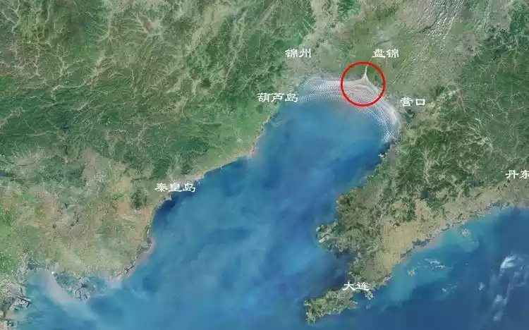
Only certain areas of the Bohai Sea and the northern Yellow Sea in my country experience varying degrees of ice formation each winter. The Red Beach National Scenic Corridor lies at the mouth of the Liaohe River in Panjin, where over 20 large, medium, and small rivers converge with the seawater. This area keeps the salinity of coastal waters below 2.5%. Lower salinity raises the freezing point. Furthermore, this area is located at China's northernmost coastline, at a high latitude and low temperatures.
Panjin, Liaoning
Panjincheck the details
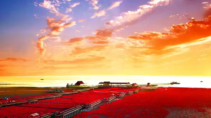
Panjin City, located in southwestern Liaoning Province, is an ecological new city thriving on its oil production and renowned for its rice. Panjin rice is renowned nationwide, served at state banquets and the Olympics. Rich in resources and beautifully landscaped, Panjin is a paradise for migratory birds, known as the "Hometown of Red-crowned Cranes" and the "Capital of Black-headed Gulls." Panjin's wetlands have been recognized by tourism organizations as "China's Most Beautiful Wetlands." But the most captivating attractions are Asia's largest reed marshes and the world-famous Red Beach. For foodies, Panjin also has something to offer. It's northern China's largest river crab producer, renowned for its fragrant rice and plump crabs, earning it the title of "China's No. 1 River Crab City" by the River Crab Branch of the China Fisheries Association. In spring, enjoy birdwatching in these stunning wetlands; in summer, explore the reed seas of cranes and marvel at the wonders of the world; in autumn, savor the plump crabs and fragrant rice while admiring the wetland scenery; and in winter, enjoy ice fishing and hot springs. The scenery is endless year-round.
Recommended month: All seasons
4311 recommendations, 8280 visits
How to get there
airplane
Nearby airports: Taoxian Airport/Xiaolingzi Airport/Jinzhou Bay Airport/Lanqi Airport/Zhoushuizi Airport
Shenyang Taoxian Airport is recommended as the first choice
There are relatively many flights to Shenyang from various places, and there are intercity buses at the airport that can directly reach Panjin Xinglongtai Passenger Station (fare 64 yuan).
Nearby are Jinzhou's Xiaolingzi Airport, Jinzhou Bay Airport, and Yingkou Lanqi Airport, which have fewer flights; Dalian Zhoushuizi Airport, which is relatively far away; and transportation to Panjin is relatively less convenient than Taoxian Airport.
train
Nearby railway stations: Panjin North Railway Station/Panjin Railway Station
There are special buses from Panjin North Station and Panjin Station to Red Beach, and the journey takes 1.5-2 hours.
Tips:
Panjin North - Raoyang Lake - Liaohe Specialty Museum - Sunshine Green Hotel - Liaohe Forest of Steles - Liaohe Wetland Park - Qin Hot Spring - Educated Youth Headquarters - Red Beach National Scenic Corridor, a total of 9 stops, ticket price 30 yuan
Shuangtaizi Bus Station (Panjin Station) - All Seasons Hotel - Hanxin Hotel - City Bus Station - Ruishi Hotel - Hexiang Community - Red Sea Hot Spring Paradise - Dawa Bus Station - Educated Youth Headquarters - Red Beach National Scenic Bridge, a total of 10 stops, ticket price 20 yuan
Self-driving
From Beijing: Beijing-Shenyang Expressway → Panhaiying Expressway (G16 Danxi Expressway) → Panjin South Expressway → National Highway 305 (Zhonghua Road) → Honghaitan Street → Honghaitan
From Shenyang: Beijing-Shenyang Expressway → Panhaiying Expressway → Exit Panjin South Expressway → Xianghai Avenue (Zhonghua Road) → Honghaitan Street → Honghaitan
From Dalian: G15 → Panjin Port Expressway → National Highway 305 (Zhonghua Road) → Honghaitan Street → Honghaitan
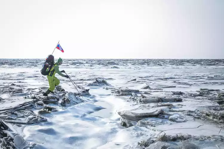
Ice hiking
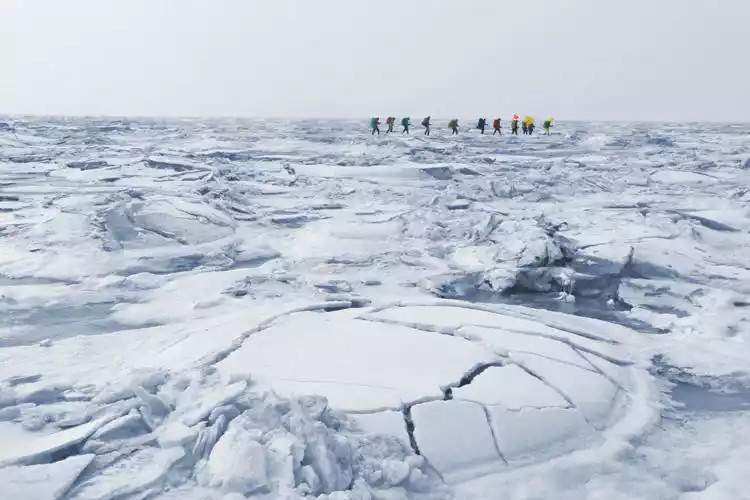
Every January and February, cold air freezes the sea surface here into ice. Tidal pressure creates ice sheets that rise from the ground in a patchwork of shapes and sizes, creating a seamless blend of crystal-clear icicles, the vast sea, and the distant sky.
This has led to the formation of vast ice fields that are rare in the world and comparable to the North and South Poles; every year it attracts outdoor enthusiasts from home and abroad to come here and experience sea hiking.
Ice area
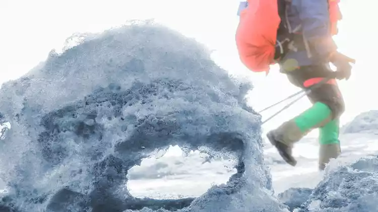
Unlike regular hiking, our journey is over the vast ocean, where there are no fixed roads or routes year-round. Hiking on the sea depends on the ice, which in turn depends on the weather and tides.
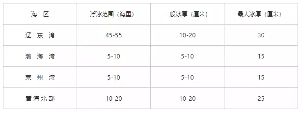
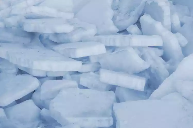
January and February are the coldest months in Liaodong Bay, with temperatures often hovering between -15°C and -30°C. Tidal pressure causes the frozen sea surface to break, accumulate, and refreeze, forming sea rivers and tidal gullies. The ice surface conditions can change daily.
The range of sea surface ice covers the entire Liaodong Bay, and the floating ice area can reach as far as fifty or sixty nautical miles. The further out to sea, the more it is basically a floating ice area.
Tips:
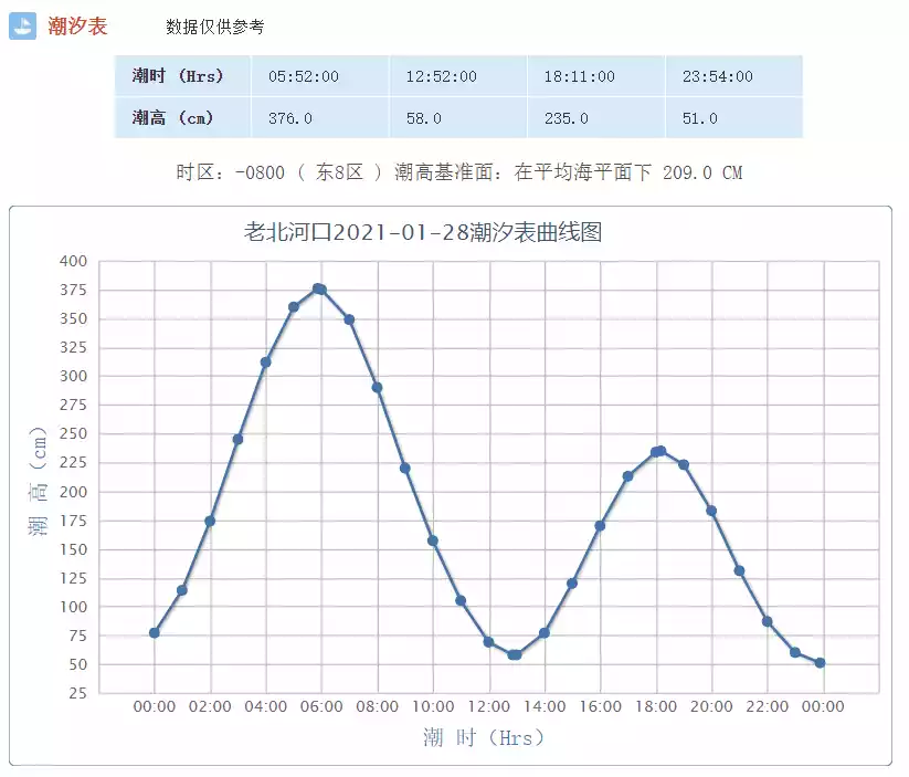
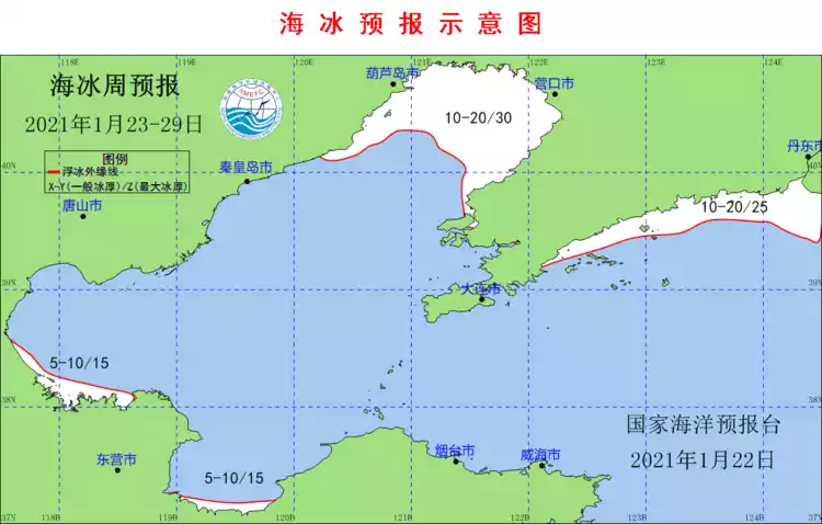
It is recommended to pay attention to the National Marine Forecasting Center and check the weekly sea ice forecast; the tide schedule for the day can be viewed on the Maritime Service Network CNSS.
Hiking area
It is mainly distributed at the mouth of the Liaohe River, starting from Yuanyang Island, extending along a coastline of about 50 kilometers on both sides of the east and west, and extending several kilometers deep into the ocean.
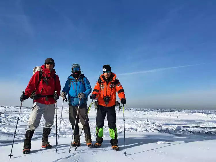
Since 2015, Liaoning Province has held the China's Northernmost Coastline Ice Crossing Challenge every year, attracting outdoor sports enthusiasts from all over the country to hike along China's northernmost coastline, through the Liaohe River Estuary Trail, and cross China's only ice zone.
Days of cold weather have created a bizarre spectacle in Panjin, where the area between the Liaohe River estuary and the Dalinghe River estuary is filled with sea at high tide and ice at low tide. The uncanny convergence of tide and river water, like the dramatic landforms shaped by the collision and compression of Earth's continental plates, has uplifted vast swathes of ice, transforming the sea ice into a natural landscape etched by knives, axes, wind erosion, and water.
Hiking difficulty
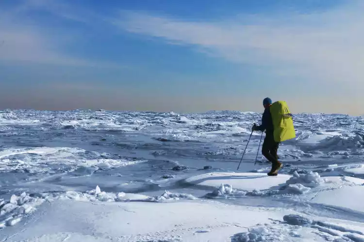
Lightweight day hike: 5-10 km
⭐⭐ (seven stars are the highest)
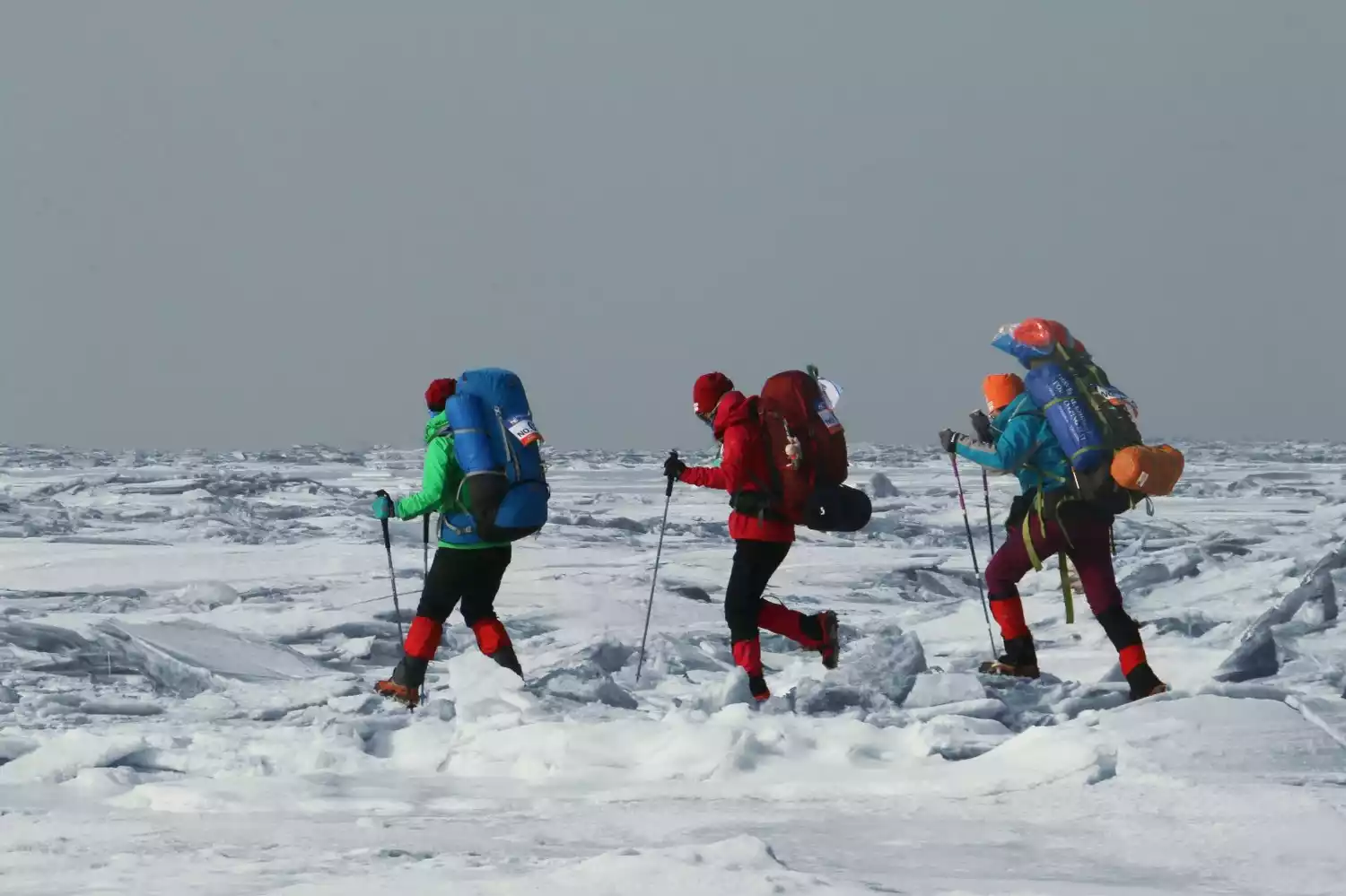
This experiential, one-day hike takes you along the ice near the coast, covering a distance of 5-10 kilometers. The ice is thick and stable, making it a low-risk and easy hike.
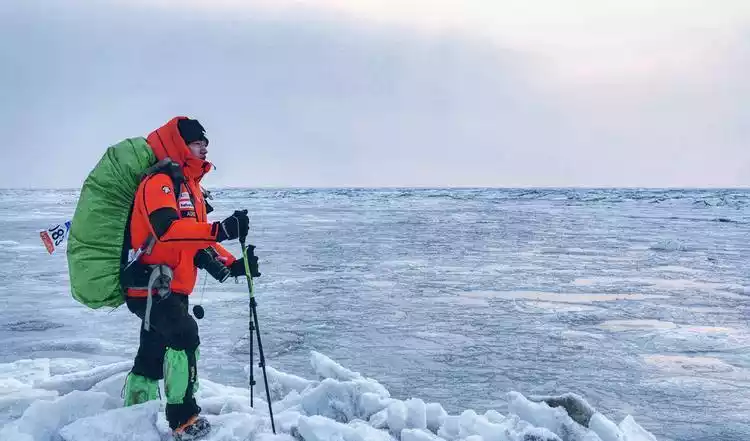
2-3 days of heavy camping: 30-55 km
⭐⭐⭐⭐⭐ (seven stars are the highest)
The multi-day, heavily loaded trek can reach over 50 kilometers, significantly increasing the difficulty and risk. Not only do you have to carry camping gear, spare clothing, food, and even spare shoes, but you also have to venture deep into the ocean, close to the pack ice, where the ice is even more crystal clear and the scenery even more breathtaking.
Tips:
The route for a 3-day, 2-night sea hiking and heavy camping trip (for reference): Red Beach Scenic Area - East Bank of Liaohe Estuary - West Bank of Liaohe Estuary - Dalinghe Estuary (total length 55 kilometers)
Precautions
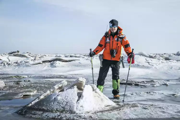
Hiking on the ice requires not only good physical fitness and strong cold-resistant equipment, but also rich experience.
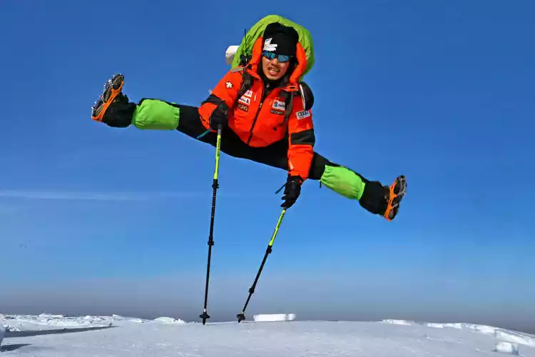
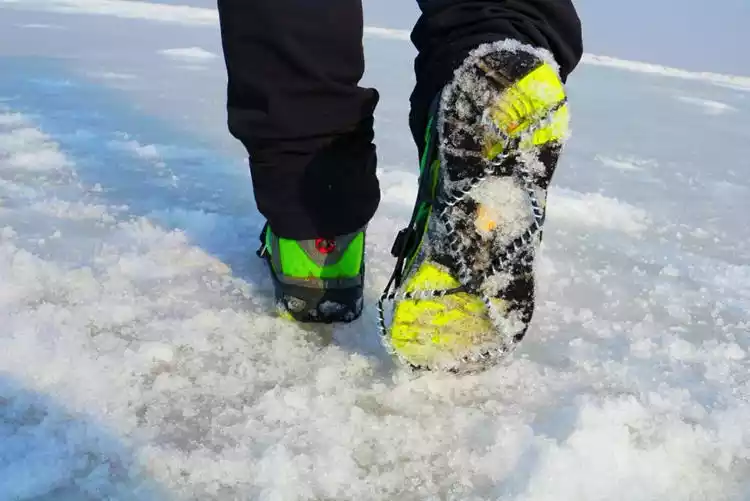
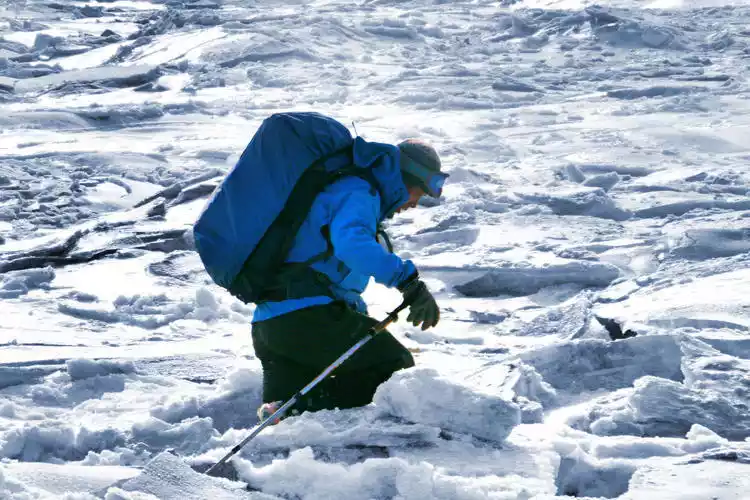
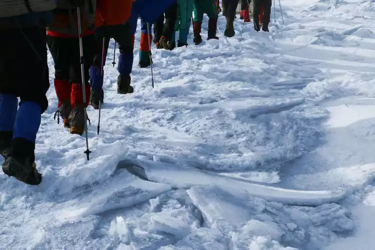
1. The ice surface is extremely slippery: Hiking is very slippery. If you slip on the hard ice surface, it may hurt at best and may even cause a fracture; you must wear crampons.
2. Complex road conditions: Due to the influence of tides, the ice surface conditions are extremely complex, with numerous tidal gullies, rivers and floating ice. If you encounter an uncrossable river, a distance of a few meters may require a detour of kilometers.
3. Undercurrents: What appears to be solid ice may be a tidal creek covered in thin ice. If you're not careful, you could easily step into the icy water. If you're not in the water too deep, it can be extremely dangerous. Getting wet is a minor issue; if you don't promptly change into dry shoes, pants, and socks, you could even risk hypothermia.
4. Extremely cold temperatures: Hiking on ice is only possible when the temperature remains low for a long period of time, and the temperature on the sea surface is usually lower than that on land. Warmth-keeping measures must be in place, otherwise frostbite is likely to occur.
Actual route (for reference)
Day 1: Sandaogou (west bank of the Liaohe River estuary) – Kudanggou (12 km, 1 km below sea level, campsite: on the shore)
Day 2: Kudanggou – Panshan Seawater Aquaculture (14 km, 2 km below sea level, campsite: aquaculture farm dam)
Day 3: Panshan Seawater Aquaculture Farm - Daling River Estuary (9 km, 1 km above sea level)
Tips:
Note: Ice crossing is different from land hiking and camping. You need to pay attention to the tide time in advance. If the tide rises at night, camping on the ice is not possible. For safety reasons, you need to return to the shore to camp every day.
Never hike alone on the ice! Never venture into the ice floe!
Equipment List Reference
camping equipment
Four-season tent (FERRINO four-person tent), sleeping bag (Black Ice G1000), moisture-proof mat (Egg Trough inflatable mat R value 5.0), backpack (35-55L)
Other equipment
Stove, gas tank (cannot be transported by express, need to buy locally), pot set, headlamp, crampons, trekking poles (with snow rings)
Electronics
Mobile phones, power banks, cameras, walkie-talkies, Beidou boxes, etc.
Clothing reference
Jackets and pants, fleece jackets and pants, thin down jackets, quick-drying underwear, quick-drying socks, high-top hiking shoes, hats, headscarves, gloves, and snow gaiter
Food preparation
2 breakfasts + 3 lunches + 2 dinners, try to have dry food as the main food for lunch.
Tips:
Sleeping bags, electronic products, spare clothes, etc. must be packed in waterproof bags to prevent them from accidentally falling into the water.