Dujiangyan Scenic Area - Baopingkou
都江堰景区-宝瓶口

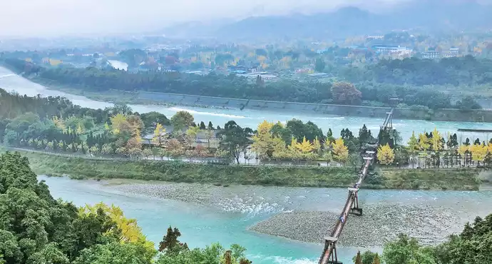
Baopingkou is the first water conservancy project entering the Dujiangyan Scenic Area, which is used to strictly control the flow of Neijiang water into the Chengdu Plain.
It is named because it looks like a bottle mouth when viewed from a high place, and it also means "blessing peace".
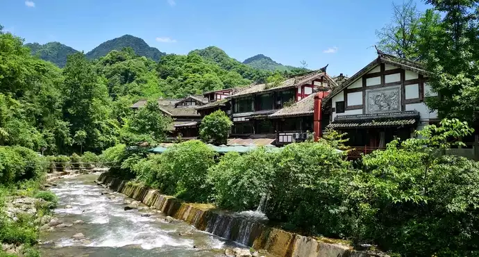
The best place to overlook Baopingkou is the top floor of Fulong Temple, where you can see the magnificent view of the surging river flowing through Baopingkou.
Introduction
Attraction Location: Dujiangyan, Sichuan Province, China (中国四川省都江堰市)
History: Baopingkou is part of the ancient Dujiangyan Irrigation System built in 256 BC during the Qin Dynasty. It serves as the "bottle-neck" that controls the flow of the Min River, regulating water distribution for irrigation and flood prevention. It has been in continuous use for over 2,200 years and is a testament to ancient Chinese hydraulic engineering.
Architecture: The site features a narrow channel carved into rock, allowing precise water flow control. The channel is flanked by observation platforms, traditional pavilions, and pathways that allow visitors to view the engineering marvel from different angles.
Cultural Value: Baopingkou is a UNESCO World Heritage Site component and a symbol of human ingenuity harmonized with nature. It is frequently studied by engineers, historians, and scholars for its innovative flood control methods.
Other Information: Visitors can view the water flow dynamics, especially during high-water seasons, and learn about the historical significance through on-site interpretive signs and guided tours.
Visiting Information
Opening Hours: 08:00–18:00
Ticket Price: Adults: CNY 90
Students: CNY 45
Seniors (60+): CNY 60Best Photo Spots: Overlook of the Bottle-Neck Channel from the main viewing platform, riverside pavilions, aerial views along walking trails
Time Reference: 1–2 hours to explore the Baopingkou area; combine with other Dujiangyan sites for a half-day tour
Where to Sleep (Nearby Hotels & Stays)
- Luxury: InterContinental Dujiangyan (都江堰洲际酒店)
Sheraton Dujiangyan Resort (都江堰喜来登度假酒店) - Mid-range: Dujiangyan Qingchengshan Hotel (都江堰青城山酒店)
Dujiangyan Oriental Hotel (都江堰东方酒店) - Budget & Boutique: Bamboo Grove Guesthouse (竹林客栈)
Dujiangyan Panda Hostel (都江堰熊猫青年旅舍)
What & Where to Eat
- Must-Try Dishes: Sichuan Hotpot (四川火锅)
Twice-Cooked Pork (回锅肉)
Gong Bao Chicken (宫保鸡丁) - Famous Spots: Dujiangyan Hotpot Restaurant (都江堰火锅店)
Tianfu Cuisine (天府食府)
Local street food near Baopingkou (宝瓶口附近小吃)
What Souvenirs to Buy
- Miniature Baopingkou models (宝瓶口微缩模型)
Postcards (明信片)
Local teas and handicrafts (地方茶叶和手工艺品)
Transportation
- By Bus: Local buses from Dujiangyan city center stop at Baopingkou (宝瓶口站)
- By Taxi/Car: About 1 hour from Chengdu city center via G4218 Expressway
- Combination Tours: Often included with Dujiangyan Scenic Area tours and nearby Mount Qingcheng (青城山)
Nearby Attractions
- Fish Mouth Levee (鱼嘴堤) – approx. 1 km, accessible via walking trail
- Flying Sand Weir (飞沙堰) – approx. 1.5 km, reachable by walking or shuttle
- Guankou Temple (观音庙) – approx. 1.8 km, reachable by walking
Tips for Visitors
- Wear sturdy walking shoes; trails near the channel can be uneven
- Visit in early morning or late afternoon for better light and fewer crowds
- Bring water and light snacks; rest areas are available
- Observe the water flow from designated platforms; climbing barriers is prohibited
- Seasonal floods provide dramatic water views but may restrict some trails
- Photography is encouraged; avoid flash near temples or sacred areas
Recommended Itineraries
- Half-Day Dujiangyan Tour: D1: Baopingkou → Fish Mouth Levee → Flying Sand Weir
Transport: walking or local shuttle - 1-Day Cultural & Nature Tour: D1: Baopingkou → Dujiangyan Scenic Area main sites → Mount Qingcheng
Transport: taxi or tour shuttle - 2-Day Extended Tour: D1: Baopingkou → Fish Mouth Levee → Flying Sand Weir
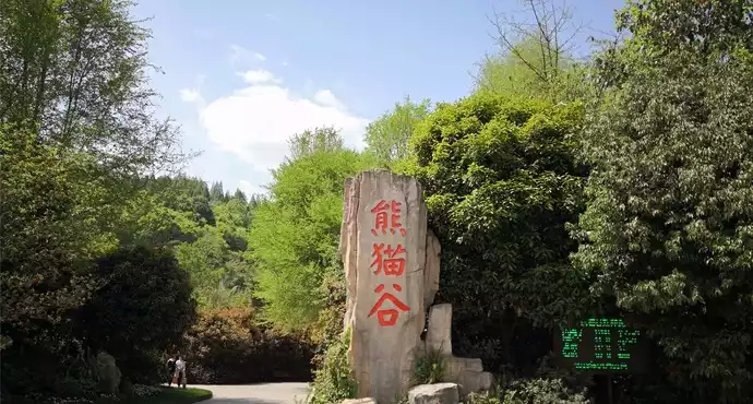
D2: China Giant Panda Garden (中华大熊猫苑) → Mount Qingcheng (青城山)
Transport: taxi or combination tour shuttle
User Reviews

Dujiangyan is a great water conservancy project built in ancient times that still benefits mankind today. It is known as the "ancestor of the world's water conservancy culture." Baopingkou is one of the Dujiangyan system projects.


Standing in the corridor between the central hall "Iron Buddha Hall" and the rear hall "Jade Emperor Hall" of Fulong Temple, you can look far into the Baopingkou. The clear blue water rushes down like a fierce dragon crossing the river, and the waves hit the cliffs and roll up thousands of layers of waves, making a roaring sound, which is very spectacular. Go down the narrow corridor in the "Nostalgia Pavilion" to the viewing trail "Huazhou Plank Road" by the river to get a close look at the spectacular scenery of "Baopingkou" - layers of waves bravely come, and waves like snow are rising.


The wisdom of the ancients brings happiness to the modern people! Baopingkou is still in use today, which makes people sigh at the wisdom of the ancients!


Not far from the scenic area, the waterway at Feishayan has a nice view.


Baopingkou is the first water conservancy project entering the Dujiangyan Scenic Area, which is used to strictly control the flow of Neijiang water into the Chengdu Plain.


We started from Chengdu, and met local solicitors at the train station. My friend and I followed them. The service was very good. They took photos for us along the way, introduced us to a lot of cultural background, and talked about the situation of Dujiangyan during the Wenchuan earthquake. If you go to Dujiangyan by yourself, there is nothing to see, because it is just a building, and there are many cultures and stories inside, which need to be understood. This is the importance of Dujiangyan.


Baopingkou acts as a "regulating gate" that can automatically control the amount of water entering Neijiang River. It is a hole dug on the long ridge of Xianshan Mountain (now known as Guankou Mountain and Yulei Mountain) that extends to Minjiang River. It is artificially dug to control the water inflow of Neijiang River. Because it is shaped like a bottle mouth and has a unique function, it is named Baopingkou. The hill left on the right side of Baopingkou is named Lidui because it is separated from the mountain. Before the opening of Baopingkou, Lidui was part of Hutouyan of Xianshan Mountain. Due to the magnificent natural landscape of Baopingkou, it is known as "Lidui Locking Gorge" and is one of the famous "Ten Scenic Spots of Guanyang" in history.


When I was in school, I often went to Qingcheng Mountain to see the water conservancy projects, but I didn’t see them much. Later, I took my husband there once.


Baopingkou is named after the Minjiang River flowing out of Baopingkou to the western Sichuan plain, Wohui Sichuan. The snow scene these days is very beautiful.


A scenic spot in Dujiangyan Scenic Area, this is a must-see attraction when you come to Dujiangyan


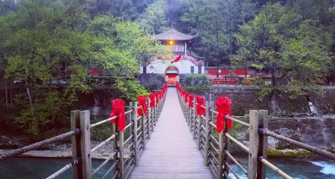
After crossing the cable bridge, we began to appreciate this grand water conservancy project. We walked upstream, so we looked at the three projects of Dujiangyan backwards. The first place we saw was Baopingkou, and the words "Li Dui" were written on the stone wall above Baopingkou. The function here seems to be to give the Neijiang water a whirlpool, which should be used to drain sand.


Dujiangyan Scenic Area is located on the Minjiang River in the west of Chengdu Plain, Sichuan Province, and is located in the west of Dujiangyan City, Sichuan Province.
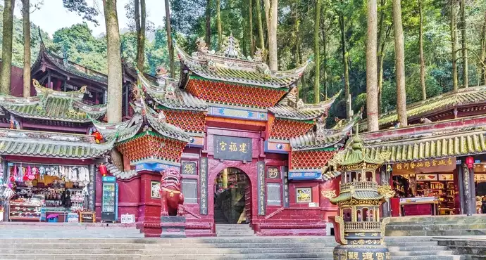
Dujiangyan is not only a world-famous ancient Chinese water conservancy project, but also a famous scenic spot. There are beautiful scenery and many cultural relics near Dujiangyan, including Fulong Temple, Erwang Temple, Anlan Cable Bridge, Yulei Pass, Lidui Park, Yulei Mountain Park, Yunu Peak, Lingyan Temple, Puzhao Temple, Cuiyue Lake, Dujiangyan Water Conservancy Project, etc.


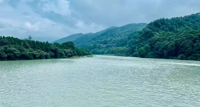
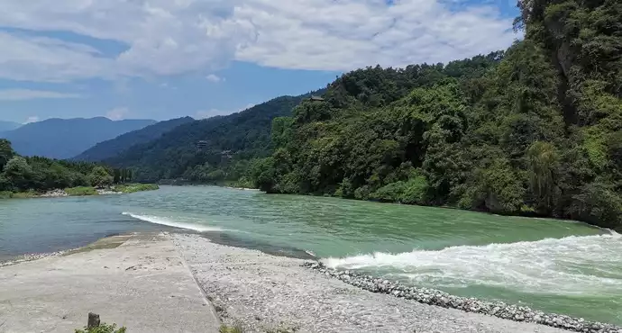
As soon as we entered the Minjiang River in Dujiangyan, Miss Cece and I exclaimed in unison: "What green water!" Indeed, the water of the Minjiang River is as green as an emerald jade belt. It is rare to see such green river water now. It may be because the water quality here is clean, or it may be because of the unique microorganisms here. In short, the color of the water presented by this Minjiang River is exactly the same as the natural color in my dream. Maybe I am tired of the yellowish river water that I see when I go out. Maybe only such river water can make people pleasing to the eye. It is comfortable for the body and mind and heals a person's tired soul.
Baopingkou got its name because it divides the river water into the shape of a bottle's mouth.


It is the crystallization of human wisdom and a feat that will benefit future generations.


Part of the Dujiangyan Irrigation Project, with three characters "Baopingkou" on the cliff


When visiting the Dujiangyan Irrigation Project, Baopingkou is not to be missed!


Baopingkou is the first water conservancy project entering the Dujiangyan scenic area. In fact, it is a canal less than 20 meters wide dug by Li Bing, but it is extremely critical. It is the throat for the Neijiang water to enter the Chengdu Plain, and is used to strictly control the flow of Neijiang water into the Chengdu Plain. It looks like a bottle mouth when viewed from a high place, hence the name, and also means "blessing peace".


One of the important parts of Dujiangyan, a good place for taking photos


I learned a lot from listening to the tour guide's explanation. The wisdom of the ancients is really great!


Baopingkou refers to an estuary that acts as a "regulating gate" and can automatically control the amount of water entering the Neijiang River. It is an artificial opening on the long ridge of Yulei Mountain that stretches to the Minjiang River. Because it is shaped like a bottle mouth and has a unique function, it is named "Baopingkou".


The magnificent Baopingkou is very spectacular, I love to cheer for it!


At an important node of the project, you can see water level marks, which were used by ancient people to measure water levels.


The river here is very turbulent and the water is very clear. If you accidentally fall in, you will probably be washed away by the river immediately. Everyone must pay attention to safety when going there.


The wisdom of the ancients and their ingenious strategies for flood control are admired by people today.


After the water flows through the Feishayan, it reaches the Baopingkou. There is a pocket on the right side to block the flow and deposit silt. The water flows through the middle, and the silt is cleared out during the annual maintenance. If a flood comes, it can overflow the pocket and be discharged downstream from the river channel on the right.
After understanding the various drainage and sand removal principles of Dujiangyan, I admire the wisdom of the ancients even more. They were able to build such a complex and sophisticated water conservancy project in that era and it is still in use today.


Baopingkou refers to an estuary that acts as a "regulating gate" and can automatically control the amount of water entering the inner river. It is an artificial opening on the long ridge of Yulei Mountain that stretches toward the Minjiang River. Because it is shaped like a bottle mouth and has a unique function, it is named "Baopingkou". The pile of stones separated by digging Yulei Mountain is called "Lidui".


Came to Chengdu, Dujiangyan, and Baopingkou to experience the real scene


It is a hole dug out on the long ridge of Jian Mountain (now known as Guankou Mountain and Yulei Mountain) extending to the Minjiang River. It was artificially dug into the throat to control the water inflow into Neijiang River. Because of its shape like a bottle mouth and its peculiar function, it is named Baopingkou.


As a key node in the Dujiangyan Irrigation Project, Baopingkou is a bit too low-key. The weather was not very good when I went there. It was foggy and I didn't take many photos. The last photo shows Baopingkou on the left and Lidui on the right.


2018.1.20 The whole family visited Dujiangyan and walked to Baopingkou. We felt Li Bing's wisdom and innovation, which turned the land of Bashu into a land of abundance.


The third link of the great water conservancy project, which is to filter river sand, has played a significant role in the fertile land of Chengdu Plain!


The Baopingkou Dam and the Feishayan Dam work together to regulate the size of the water flow and are the key to controlling the water inflow into the Neijiang River.


The Fish Mouth, the Feishayan and the Baopingkou are really useful. You will only understand their mysteries after listening to the storytelling explanation of the tour guide. In short, the Dujiangyan Irrigation Project consists of three major parts: the Fish Mouth Diversion Dike, the Feishayan Spillway and the Baopingkou Inlet. It scientifically solves the problems of automatic diversion of river water, automatic sand discharge and control of water inlet flow, eliminates floods and makes the western Sichuan plain a "land of abundance" where "water and drought are controlled by people".


After listening to the guide's introduction and then seeing the actual scene, I felt that the meaning was very different. The location of Baopingkou was originally a mountain. In order to divert the water, Li Bing and his companions used the principle of thermal expansion and contraction to first set fire to the mountain and then pour river water on the mountain. This repeated process caused the mountain to crack, greatly shortening the time for digging the gap. It was amazing!


Baopingkou is the outlet of clean water after passing through Yuzui and Feishayan.


As a representative of ancient Chinese water conservancy projects, we can appreciate the wisdom of the ancients. Moreover, this water conservancy project is environmentally friendly and is a combination of human wisdom and nature.


I went there during the summer vacation, and because it was the rainy season, I could see the function of Baopingkou clearly.


Bang bang bang bang bang bang bang bang bang bang bang


在都江堰景區的前端,是整個都江堰水利工程引水入成都平原的部分。


It was winter when I went there, so the water flow was not large, but it was enough to get a glimpse of its appearance.


Dujiangyan is really worth visiting. The water at Baopingkou is particularly green and clear. I went there in winter. You can go there during the flood season. The scenery should be better at that time. Most importantly, you can also feel the wisdom of the ancient people.


An ancient water conservancy project in Dujiangyan City is still in use today, which is truly a wonder.


It's not far from the scenic area. I was surprised to see the green river water. It's so beautiful! Baopingkou was blasted out of the mountain. After passing Baopingkou, the water flows and becomes wider.


There are many intercity trains from Chengdu to Dujiangyan, the journey takes about 30 minutes and costs 10-15 yuan. Xipu Station is relatively far from the urban area. I personally think it is better to choose Chengdu Station if you live in the urban area. There are many intercity trains from Chengdu to Dujiangyan, the journey takes about 30 minutes and costs 10-15 yuan. Xipu Station is relatively far from the urban area. I personally think it is better to choose Chengdu Station if you live in the urban area.


It is a hole dug out on the long ridge of Jianshan Mountain (now called Guankou Mountain and Yulei Mountain) that stretches toward the Minjiang River. It was artificially dug into the throat to control the water inflow of Neijiang River. Because it is shaped like a bottle mouth and has a unique function, it is named Baopingkou. The hill left on the right side of Baopingkou is named Lidui because it is separated from the mountain. Before the Baopingkou was dug, Lidui was part of Hutouyan of Jianshan Mountain.


It is a hole dug out on the long ridge of Jianshan Mountain (now called Guankou Mountain and Yulei Mountain) that stretches toward the Minjiang River. It was artificially dug to control the water inflow into Neijiang River. Because it is shaped like a bottle mouth and has a unique function, it is called Baopingkou.


Baopingkou is the most beautiful scenery in Dujiangyan Scenic Area. It is the first stop when visiting the three major water conservancy projects. It is suitable for taking photos.


Baopingkou is a man-made throat that controls the water inflow of Neijiang River. It is named Baopingkou because it is shaped like a bottle mouth and has a unique function. It has the function of regulating water flow. The hill to the right of Baopingkou is named Lidui because it is separated from the mountain. The water system of the entire Dujiangyan is green and blue, like a sapphire, which is very beautiful and spectacular.


Baopingkou is a hole cut on the long ridge of Yulei Mountain that stretches to the Minjiang River. Its narrow passage forms an automatically adjustable water gate, controlling the flow of Neijiang River and protecting the irrigation network of Neijiang River.


Baopingkou is a large hole dug by Li Bing and his sons in the Qin Dynasty on the ridge that stretches to the Minjiang River. It is used as a valve to control the water inflow into the Neijiang River. Therefore, Baopingkou is equivalent to the throat of the entire Dujiangyan water conservancy project, and its importance is self-evident. Looking across Baopingkou from Lidui, the turquoise water is very beautiful.


Baopingkou is a hole dug out on the long ridge of Jianshan Mountain (now known as Guankou Mountain and Yulei Mountain) that stretches toward the Minjiang River. It is artificially dug to control the water inflow into the Neijiang River. Because of its shape like a bottle mouth and its unique function, it is named Baopingkou. It strictly controls the flow of river water into the Chengdu Plain.


One of the famous scenic spots in Dujiangyan. It is a hole dug on the long ridge of Jianshan (now called Guankoushan and Yuleishan) that stretches to the Minjiang River. It is artificially dug to control the water inflow of Neijiang River. Because it is shaped like a bottle mouth and has a unique function, it is named Baopingkou. The hill left on the right side of Baopingkou is separated from the mountain, so it is named Lidui. Before the Baopingkou was dug, Lidui was part of Hutouyan of Jianshan.
According to the characteristics of water flow and terrain, Li Bing dug a wedge-shaped opening with a bottom width of 17 meters at a gentle slope. The gorge is 19 meters wide in the dry season and 23 meters wide in the flood season. According to the "Yongkang Military Records", "During the spring ploughing season, it is as much needed as gold, so it is called 'Jin Guankou'". Therefore, Baopingkou was also known as Jin Guankou in ancient times. Baopingkou is the throat of Neijiang River and a key water conservancy facility for Neijiang River to "control floods and droughts". Due to the magnificent natural landscape of Baopingkou, it is known as "Li Dui Locking Gorge" and is one of the famous "Ten Scenic Spots of Guanyang" in history.
The width and bottom height of the Baopingkou are strictly controlled. The ancients carved dozens of divisions on the rock wall and named it "Shui Ze", which is the earliest water level ruler in my country.


Baopingkou is the most beautiful place in Dujiangyan. Let’s not talk about the significance of its construction. The good water can really make people feel refreshed. Just looking at the water will not make you feel bored.


It is a hole dug out on the long ridge of Jianshan Mountain (now called Guankou Mountain and Yulei Mountain) that stretches toward the Minjiang River. It was artificially dug into the throat to control the water inflow of Neijiang River. Because it is shaped like a bottle mouth and has a unique function, it is named Baopingkou. The hill left on the right side of Baopingkou is named Lidui because it is separated from the mountain. Before the Baopingkou was dug, Lidui was part of Hutouyan of Jianshan Mountain.


Baopingkou acts as a "regulating gate" that can automatically control the amount of water entering Neijiang River. It is a hole dug on the long ridge of Xianshan Mountain (now known as Guankou Mountain and Yulei Mountain) that extends to Minjiang River. It is artificially dug to control the water inflow of Neijiang River. Because it is shaped like a bottle mouth and has a unique function, it is named Baopingkou. The hill left on the right side of Baopingkou is named Lidui because it is separated from the mountain. Before the opening of Baopingkou, Lidui was part of Hutou Rock of Xianshan Mountain. Due to the magnificent natural landscape of Baopingkou, it is known as "Lidui Locking Gorge" and is one of the "Ten Scenic Spots of Guanyang" in history.


The season was just right, with green water flowing slowly.


The width and bottom height of Baopingkou are strictly controlled. The ancients carved dozens of divisions on the rock wall and named them "Shui Ze", which is the earliest water level scale in my country. "Historical Records" said: "These channels are all navigable. If there is excess water, it can be used for irrigation, and the people benefit from it." "Song History" has "the water level is one foot, and it stops when it reaches ten feet. When the water reaches six feet, the flow is sufficient for use." "Yuan History" has a record that "it is drawn with a ruler, and the ratio is ten to one. When the water reaches nine, the people are happy, but when it exceeds, they are worried, and when it is empty, they are in trouble."


Baopingkou is an important part of the Dujiangyan Scenic Area. The rushing Minjiang River narrows here, and it looks like the mouth of a vase. You can walk to the pavilion on the other side to watch it.


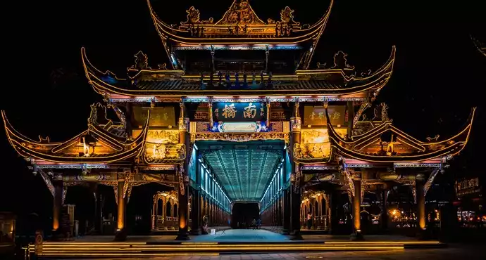
It doesn't have any obvious features, but it is inside the temple, so it is equivalent to a small scene inside the temple. The first photo was taken at Nanqiao.


It is a hole dug out on the long ridge of Jian Mountain (now known as Guankou Mountain and Yulei Mountain) extending to the Minjiang River. It was artificially dug into the throat to control the water inflow into Neijiang River. Because it looks like a bottle mouth and has a unique function, it is named Baopingkou.


A hole cut out on the long ridge of Yulei Mountain stretching toward the Minjiang River is artificially carved to control the water inflow to Neijiang River. Because of its shape like a bottle mouth and its unique function, it is named Baopingkou. Due to its magnificent natural landscape, Baopingkou is known as "Li Dui Suoxia" and is one of the famous "Ten Scenic Spots of Guanyang" in history.


Very beautiful, very spectacular and well worth a visit.


The first thing you see when you enter the scenic area is Baopingkou. Baopingkou is quite narrow. You can see the three characters Baopingkou on the cliff on the river bank.


When visiting historical and cultural sites, you have to follow a tour guide. Listening to the tour guide can help you gain a deeper understanding of the attractions.


Not bad, it looks good from a distance, and it is also part of the diversion, otherwise the downstream will also suffer~~


A scenic spot in the Dujiangyan Scenic Area, the river becomes narrower here, and the river water rushes down here. The water here is very strong and quite spectacular.


The color of the water is so magical, the green mountains and green waters are so interesting


Words cannot describe it well, you need to go there to experience it in person.


I am deeply impressed by the ancients. The artificially excavated water inlet~


A great project that will benefit future generations, an ingenious application of physics


Kou refers to the estuary that acts as a "regulating gate" and can automatically control the water inflow into Neijiang River. It is an opening artificially dug on the long ridge of Yulei Mountain extending to the Minjiang River. Because it is shaped like a bottle mouth and has peculiar functions, it is named "Baopingkou". The pile of stones separated by the excavation of Yulei Mountain is called "Lidui".


Magnificent mountains and rivers, immortal engineering. The river water sobs, singing endlessly about the romance of the world. . . . . .


In the Dujiangyan Scenic Area, just follow the map on the ticket


Baopingkou is an artificial opening on the long ridge of Yulei Mountain extending to the Minjiang River. It is the throat that controls the water inflow into Neijiang River. It is named Baopingkou because of its bottle-mouth-like shape and significant function.